Synthetic dataset of Luxembourg’s citizens (published by LNDS)
The dataset has been created by using the open-source code released by LNDS (Luxembourg National Data Service). It is meant to be an example of the dataset structure anyone can generate and personalize in terms of some fixed parameter, including the sample size. The file format is .csv, and the data are organized by individual profiles on the rows and their personal features on the columns. The information in the dataset has been generated based on the statistical information about the age-structure distribution, the number of populations over municipalities, the number of different nationalities present in Luxembourg, and salary statistics per municipality. The STATEC platform, the statistics portal of Luxembourg, is the public source we used to gather the real information that we ingested into our synthetic generation model. Other features like Date of birth, Social matricule, First name, Surname, Ethnicity, and physical attributes have been obtained by a logical relationship between variables without exploiting any additional real information. We are in compliance with the law in putting close to zero the risk of identifying a real person completely by chance.
Text and data re-used from Open Data Platform Luxembourg
What you will learn
Learn about the concept of a synthetic data set
Learn about LNDS - Luxembourg National Data Service (LNDS) launched in December 2023. Visit www.lnds.lu
Explore statistics of Luxembourg and its citizens.
Build a dashboard with the data
Data set
Title: Representative synthetic dataset of Luxembourg’s citizens
Source: LNDS
Instructions
Download the data.
Connect to the data using your favorite Dashboarding tool.
We will use Tableau Desktop for the demo.

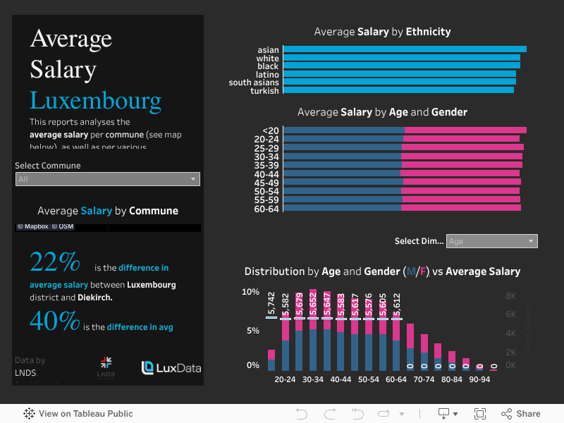
Example visualization
Please find example dashboard below.
TIP: How to display the Communes of Luxembourg on a map
We created a join with a shapefile of the communes of Luxembourg in order to display the communes on a map - not all dashboarding tools display all communes / districts / municipalities etc of every country worldwide. For this reason we often need to fetch the shapefiles from external source. Check out this link and download the file communes4326.geojson. https://data.public.lu/en/datasets/limites-administratives-du-grand-duche-de-luxembourg/
We will cover more on this topic at a later post. Or contact us for questions.